Location
National Land Commission Secretariat
Geographic Names Standardized Category: Open
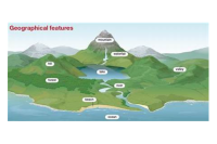
This data contains the standardized village names in Bhutan achieved through a collaborative effort led by the Department of Local Governance and Disaster Management (DLGDM), with participation from key stakeholders including the National Land Commission Secretariat (NLCS), Department of Civil Registration and Census (DCRC), Department of Culture and Dzongkha Development (DoCDD), and the Election Commission of Bhutan (ECB).
Keywords: [#standardized#village#dzongkhag]
Department of Geology and Mines
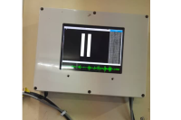
Dzongkhag Intensity Meter Station Category: Open
To monitor and assess ground shaking intensity at specific sites during an earthquake, intensity meters are installed in every Dzongkhag. These meters detect seismic activity to support post-disaster analysis. Stations are primarily located in populated areas to facilitate effective response and relief measures in regions prone to severe damage.
Keywords: [#Earthquake Station]
Department of Geology and Mines
Landslide Inventory of Samdrupjongkhar Dzongkhag Category: Open
Samdrup Jongkhar Dzongkhag, situated in southeastern Bhutan, is highly prone to landslides due to its fragile geology, high monsoon rainfall, and increasing infrastructure development in steep terrain. Recognizing its vulnerability, field validations were carried out over two consecutive phases. The first phase, conducted in 2021-2022, was limited in coverage due to logistical constraints. A more targeted second phase (2022–2023) focused on areas with significant impacts on settlements and infrastructure.Out of the 11 gewogs, landslide data were collected from 8 gewogs, with Dewathang Gewog accounting for the highest share (35%) of the total. Field verification showed that 87% of the landslides are active, and the majority are located along roads, directly affecting transportation and nearby communities.The primary triggering factors include road undercutting, intense rainfall, and fragile geological conditions. The landslides are mainly composed of phyllite, shale, siltstone, coal, gneiss, and quartzite, rock types that are often highly weathered, fractured, and susceptible to failure, especially during monsoon periods.Although validations were conducted over two phases, full coverage of the Dzongkhag was not achieved due to time, resource limitations, and difficult terrain. The current inventory emphasizes high-impact areas, while remote or less accessible regions remain unassessed, highlighting the need for future comprehensive risk mapping and mitigation planning.
Keywords: [#Geohazards]
Department of Geology and Mines
Landslide Inventory of Samtse Dzongkhag Category: Open
Samtse Dzongkhag, located in Bhutan’s southern foothills, is among the most landslide-prone regions in the country due to its fragile geology, intense monsoon rainfall, and increasing anthropogenic activities. Geologically, the area lies within the tectonically active Siwalik and Lesser Himalayan zones and is traversed by major fault systems, including the Main Frontal Thrust (MFT) and Main Boundary Thrust (MBT), as well as numerous local faults and folds. These structural features have fractured and deformed the rock mass, which is primarily composed of highly to completely weathered phyllite, quartzite, sandstone, and siltstone, all of which are weak and highly susceptible to failure when saturated.With annual rainfall often around 4,000 mm, coupled with widespread slope disturbances from road construction, riverbank erosion, deforestation, and settlement expansion, landslides have become a recurring hazard. Field validation confirmed that 9 out of 15 gewogs, particularly Samtse and Phuentshopelri, are severely impacted. A total of 59 landslides were documented, most of which remain active and are concentrated along thrust zones. Among these, 16 landslides (27%) were identified as critical due to their high vulnerability to settlements and key infrastructure.The study focused on landslides with direct or observable impacts on settlements and infrastructure. Remote or less accessible areas were excluded due to time and logistical constraints but should be included in future assessments, considering the evolving and uncertain nature of landslide hazards.
Keywords: [#Geohazards]
Department of Geology and Mines
Landslide Inventory of Zhemgang Dzongkhag view Category: Open
Zhemgang Dzongkhag, located in central Bhutan, exhibits localized but significant landslide activity, driven by steep terrain, fragile lithology, and human-induced disturbances. Out of eight gewogs, landslide data were collected from three gewogs, with a notable 77% of the events concentrated in Singkhar Gewog, highlighting a high-risk zone in the district.The lithology around the recorded landslides includes gneiss, granite, schist, phyllite, and quartzite, which under the deformed and fractured conditions are particularly vulnerable to failure when saturated by rainfall. These geological weaknesses are compounded by slope modifications from developmental activities.A total of 13 landslides were recorded. Among them, 54% are active, 23% suspended, and 23% dormant, reflecting varying levels of instability. The main triggering factors identified were road undercutting and climatic influences, especially intense rainfall. Two landslides located below Singkhar Primary School and in Laylang under Ngangla Gewog were classified as critical due to their proximity to settlements, school infrastructure, and roads used by commuters.Data were collected from only three gewogs due to limited time and resources. Remote or less accessible areas were not surveyed, and their landslide risk remains undocumented. These areas should be included in future assessments to support comprehensive hazard mapping and mitigation planning.
Keywords: [#Geohazards]