Boundaries
Department of Forests and Park Services
Land Use Land Cover 2016 Category: Common
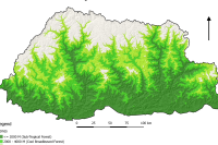
The LULC (2016) land cover assessment shows a national forest cover of 70.77% (excluding shrubs), of which 45.94% is Broadleaf, 13.53% is Mixed Conifer, 6.02% is Fir, 2.64% is Chir pine and 2.64% is Blue pine. The Alpine Scrub is 3.39%, Shrubs constitute 9.74%, while cultivated agricultural land and meadows account for 2.75% and 2.51% respectively. The snow cover constitutes 5.35% and rocky outcrops 4.15% while water bodies, built up areas, non-built up areas, landslides and moraines constitute less than 1% each
Keywords: [#land use#land cover#settlement#road#water#snow#vegetation#agriculture#forest#grassland]