Boundaries
Department of Forests and Park Services
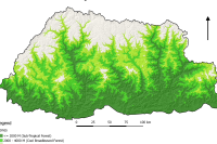
Land Use Land Cover 2016 Category: Common
The LULC (2016) land cover assessment shows a national forest cover of 70.77% (excluding shrubs), of which 45.94% is Broadleaf, 13.53% is Mixed Conifer, 6.02% is Fir, 2.64% is Chir pine and 2.64% is Blue pine. The Alpine Scrub is 3.39%, Shrubs constitute 9.74%, while cultivated agricultural land and meadows account for 2.75% and 2.51% respectively. The snow cover constitutes 5.35% and rocky outcrops 4.15% while water bodies, built up areas, non-built up areas, landslides and moraines constitute less than 1% each
Keywords: [#land use#land cover#settlement#road#water#snow#vegetation#agriculture#forest#grassland]
Department of Forests and Park Services
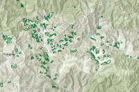
Community Forests Category: Common
Community Forests (CF) are any area of State Reserved Forest Land (SRFL) designated for management by a local community. The Department facilitates establishment of Community Forest to encourage sustainable management of trees and non-wood forest produce by the community to derive socio-economic and environmental benefit.
Keywords: []
Department of Forests and Park Services
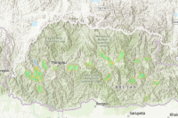
Forest Management Units Category: Common
Forest Management Units (FMU) are designated State Reserved Forest Land (SRFL) managed as production forests under an approved Management Plan primarily for production of timber, firewood, and other forest produce.
Keywords: []