Society
National Soil Services Centre
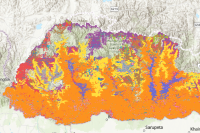
LULC 2010 Category: Common
This dataset is the Land Cover Map of Bhutan (2010). It represents the occurrence and distribution of different types of Land Use and Land Cover in Bhutan. The LULC classes listed here shows Forest cover of 70.46% (Excluding shrubs) with Broadleaf (62.43%), Mixed Coniferous (22.69%), Fir (6.77%), Blue Pine (2.96%), Chir Pine (3.98%) and 1.16% of Broadleaf with conifer. Likewise, Shrubs cover 10.81%, agriculture land and meadows cover 2.93% and 4.10% respectively. The snow cover constitutes 7.44%, bare areas with 3.20%. Marshy areas, non-built areas, built up areas, water bodies and degraded areas with less than 1% each.The average overall map accuracy at the national level is 97.91% with 95.67% minimum and 100.15% maximum at 95% Confidence Level.
Keywords: [#Planning]