Geoscientific information
National Land Commission Secretariat
GNSS Stations (CORS) Category: Common
The Continuously Operating Reference Stations (CORS) Network provides Global Navigation Satellite System (GNSS) data, supporting three dimensional positioning, meteorology, space weather, and geophysical applications throughout the Bhutan.
Keywords: [#cors#station#dzongkhag]
Department_of_Geology_and_Mines
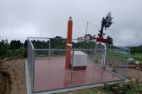
Source Monitoring Station Category: Open
The establishment of the earthquake monitoring station commenced in 2015 and was successfully completed in 2019. Its primary objective is to disseminate crucial earthquake-related information to enhance public awareness and preparedness. Recently, the Department of Geology and Mines (DGM) has been processing waveform data to verify earthquake occurrences. This analysis plays a vital role in generating a seismicity map, which helps identify regions prone to seismic activity. Furthermore, these efforts contribute to delineating possible active faults within the country, strengthening the understanding of Bhutan’s seismic landscape and supporting disaster mitigation strategies.
Keywords: [#Geophysics#Earthquake#station]
Department_of_Geology_and_Mines
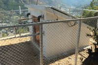
Dzongkhag Intensity Meter Station Category: Open
To monitor and assess ground shaking intensity at specific sites during an earthquake, intensity meters are installed in every Dzongkhag. These meters detect seismic activity to support post-disaster analysis. Stations are primarily located in populated areas to facilitate effective response and relief measures in regions prone to severe damage.
Keywords: [#Earthquake Station]
Department_of_Geology_and_Mines
Gewog Intensity Meter Station Category: Open
To effectively monitor and assess the intensity of ground shaking during seismic events, intensity meters have been strategically installed across all gewogs, with the exception of four: Soe and Lingzhi in Thimphu Dzongkhag, and Laya and Lunana in Gasa Dzongkhag. These instruments are designed to detect and record seismic activity in real time, providing critical data that supports detailed post-earthquake analysis and damage assessment.The placement of these stations is prioritized in densely populated or high-risk areas to enhance situational awareness during emergencies. By capturing localized intensity measurements, they play a vital role in guiding timely and informed response actions, facilitating the coordination of relief efforts, and strengthening disaster preparedness in regions susceptible to significant seismic impact.
Keywords: [#Geophysics#Earthquake#station#gewog]