Environment
Department of Geology and Mines
Landslide Inventory of Samdrupjongkhar Dzongkhag Category: Open
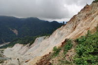
Samdrup Jongkhar Dzongkhag, situated in southeastern Bhutan, is highly prone to landslides due to its fragile geology, high monsoon rainfall, and increasing infrastructure development in steep terrain. Recognizing its vulnerability, field validations were carried out over two consecutive phases. The first phase, conducted in 2021-2022, was limited in coverage due to logistical constraints. A more targeted second phase (2022–2023) focused on areas with significant impacts on settlements and infrastructure.Out of the 11 gewogs, landslide data were collected from 8 gewogs, with Dewathang Gewog accounting for the highest share (35%) of the total. Field verification showed that 87% of the landslides are active, and the majority are located along roads, directly affecting transportation and nearby communities.The primary triggering factors include road undercutting, intense rainfall, and fragile geological conditions. The landslides are mainly composed of phyllite, shale, siltstone, coal, gneiss, and quartzite, rock types that are often highly weathered, fractured, and susceptible to failure, especially during monsoon periods.Although validations were conducted over two phases, full coverage of the Dzongkhag was not achieved due to time, resource limitations, and difficult terrain. The current inventory emphasizes high-impact areas, while remote or less accessible regions remain unassessed, highlighting the need for future comprehensive risk mapping and mitigation planning.
Keywords: [#Geohazards]
Department of Geology and Mines
Landslide Inventory of Zhemgang Dzongkhag view Category: Open
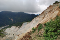
Zhemgang Dzongkhag, located in central Bhutan, exhibits localized but significant landslide activity, driven by steep terrain, fragile lithology, and human-induced disturbances. Out of eight gewogs, landslide data were collected from three gewogs, with a notable 77% of the events concentrated in Singkhar Gewog, highlighting a high-risk zone in the district.The lithology around the recorded landslides includes gneiss, granite, schist, phyllite, and quartzite, which under the deformed and fractured conditions are particularly vulnerable to failure when saturated by rainfall. These geological weaknesses are compounded by slope modifications from developmental activities.A total of 13 landslides were recorded. Among them, 54% are active, 23% suspended, and 23% dormant, reflecting varying levels of instability. The main triggering factors identified were road undercutting and climatic influences, especially intense rainfall. Two landslides located below Singkhar Primary School and in Laylang under Ngangla Gewog were classified as critical due to their proximity to settlements, school infrastructure, and roads used by commuters.Data were collected from only three gewogs due to limited time and resources. Remote or less accessible areas were not surveyed, and their landslide risk remains undocumented. These areas should be included in future assessments to support comprehensive hazard mapping and mitigation planning.
Keywords: [#Geohazards]