Boundaries
Department_of_Geology_and_Mines
Geologic Map of Bhutan Category: Open
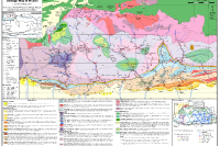
Featured in the Journal of Maps in 2011, this geological map presents a newly compiled 1:500,000-scale representation of Bhutan, along with neighboring areas in India and southern Tibet. Assembled from the most recent and comprehensive mapping datasets available at the time, it offers a significantly enhanced level of structural detail compared to earlier geological maps of the region. Bhutan’s geology is broadly categorized into four major lithological units, arranged from south to north: the Siwalik Group, the Lesser Himalayan Zone, the Greater Himalayan Zone, and the Tethyan Himalayan Zone. Alongside this, the antiformal tectonic window exposing Lesser Himalayan units with the Greater Himalaya, and the synformal klippe of Tethyan Himalayan units—both regarded as characteristic structural features of the Himalayas are also mapped in the Bhutanese Himalaya.