Boundaries
National Land Commission Secretariat
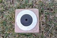
GPS Stations (Second Order) Category: Open
The Secondary Station Control Coordinates are established by means of GNSS observation data for a duration of 1 to 3 hour. These coordinates are processed and adjusted by Total Trimble Control Software (TTC). The accuracy of the coordinates has been achieved at reasonable level for mapping specifications or standards of 10 cm cadastral tolerances.
Keywords: [#control point#secondary control#coordinates#benchmark]